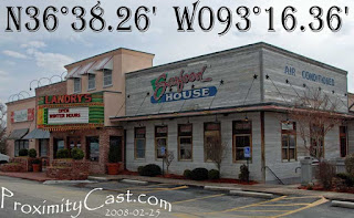
The ideal method to obtain Latitude and Longitude for labeling ProximityCast pictures is with a GPS. That is not always practical for some since we are in a time of transition and change. Therefore this blog entry will detail how to obtain coordinates from Google Maps for labeling your ProximityCast picture contributions. Hopefully this will allow those of you who don't have a GPS to still contribute your "Establishment" photographs to ProximityCast.com when you want too.
For this demonstration we will use Landry's Seafood House in Branson Missouri.
Before attempting this method you should have already been to and taken the picture at the establishment location so you will have some familiarity with the location as you attempt to find the building on Google Maps.
BLOCKED_IMAGE-LandrysInBransonA
You can type what information you have into the search box: e.g. Landry's Seafood House Branson, MO Then click "Search Maps" to hopefully get you into the ballpark. You will then want to zoom in and switch to Satellite view if not already there.
Zoomed In Satellite view
BLOCKED_IMAGE-LandrysInBransonB
Once zoomed in you want to try to positively identify the the establishment building and the point from which you took the picture.
Three Potential Establishment Candidates
BLOCKED_IMAGE-LandrysInBransonC
I used Google Maps to get me in the ballpark prior to taking my trip to this establishment. I had no idea whether the restaurant was on the right or left side of the rode. I had no idea if the location was accurate on Google Maps, but it was a place to start. I identified three possible buildings that could have been Landry's Seafood House. After arriving on site and getting my picture I had the advantage of freshly obtained familiarity with the area to make a POSITIVE ID on Google Maps. So was it location 1, 2, or 3?
BLOCKED_IMAGE-LandrysInBransonD
Besides now knowing what side of the rode the building was on, I was also able to make a POSITIVE ID by the signature marquee Landry's seems to have standard on their seafood house restaurants. So, it was now easily obvious that building #2 was the location I needed to identify.
How to Determine Coordinates: Info found here!
BLOCKED_IMAGE-LandrysInBransonE Once you have the green arrow pointing to the spot where you stood to take the photo you can highlight the Latitude and Longitude and paste them directly onto the picture in your Post Processing software.
BLOCKED_IMAGE-LandrysInBransonF Then you can edit the pasted coordinates as desired. Here I replaced the + with a "N" for northern hemisphere for the latitude, and I replaced the - with a "W" for the western hemisphere for the longitude portion. I also removed the comma then simply resize the image for uploading and we are good to go with the use of a GPS.
I hope this entry will be found useful and I look forward to seeing the places you contribute!
Till next time,
ciao my friends!


No comments:
Post a Comment