ProximityCast.com

Monday, March 31, 2008

Site Promotion with a Benefit

I've been busy coding and still have much to do, but if a site is ever to go anywhere promotion is a necessary component also. The big question: "How to stimulate interest and traffic in the site?" Promotion can be as much of a full time job as coding. It has sadly been neglected up to this point. Picking what to work on is sometimes a love/hate relationship. Anyhow here is the Facebook component of the promotion puzzel:

I have not tried this in MySpace or Bebo, but the concept should still work. If you want to meet a friend at a particular place, ask a date to go to dinner, or whatnot: CONSIDER POSTING A PROXIMITYCAST PICTURE of the place of interest in a message to your friend, date, etc. Sorry for shouting... smile.
Here is the nice things about using ProximityCast for this:

  1. ProximityCast pictures or location oriented!

  2. It is easy to get the link of a desired picture location!

  3. If you can't find the place you want, it is easy to submit your own picture of the place!


NOTE: See Authorized Social Sharing post for the new approved method for getting a link to share in a social networking site.


See... As easy as 1,2,3. Impress your date or friend by showing them exactly what you have in mind.
Okay, so how do I get the link to a desired location to post in my message?


  • Cast for the desired category in the area of interest.

  • Click MAP VIEW when cast completes.


  • In the SideBar click the desired establishment to make the Info Popup appear.


Till next time,
ciao my friends!

Improved Category Selector

I have known an improved category selector was necessary for a long time. As the category list grew longer it was simply too tedious to wade through all the possibilities. Once again thanks and appreciation to my friend Peter for inspiring me to get busy and tackle this item.

The new improved category is now composed of two parts:

  1. A top textbox where you can simply start typing in whatever it is you want to find. The textbox uses auto suggest to help you rapidly arrive at the desired category.

  2. The old drop down list box. Sometimes we might not really know what we are interested in, so this allows users to browse all the available categories.


If the dropdown is utilized, it will automatically populate the textbox above.
If after using the dropdown you use the textbox before clicking "Perform ProximityCast" the textbox will show a different category than the dropdown. The textbox entry will be the category utilized to perform the search.

Minor Bug


There is a minor bug with the auto suggest tool. If you type very fast, such as "fo" ford will appear twice and the other fo???? possibilities will not be shown. Sorry for this hopefully minor inconvenience.

Credits


A three part article by Nicholas C. Zakas helped me get over the hump to create the autosuggest textbox. Much appreciation Nicholas! I looked high and low for a reference I liked. Your's proved to be straight forward, clear and easy to implement. Thank you!
By the way, take a look at Nicholas's website and it is easy to tell that he is high energy and very talented!

Till next time,
ciao my friends!

Coordinates from Google Maps the easy way

Much thanks to my friend Peter for telling me about an easier way to get Latitude and Longitude coordinates from Google Maps. This reminds me of the time I was a guest IP (instructor pilot) for a couple of students teaching instrument flight for the Army. We were to cover holding procedures this day. I started going over the textbook method I had been taught and continued to teach. The students interrupted me and asked about the method their instructor had taught them. It was new to me, but highly superior to the way I had been doing and teaching the procedure.
That's what happens sometimes when we work in a box without adequate outside interaction. Anyhow if you need to or just want to find the coordinates for a spot on Google Maps here is all you need to do:

Steps to get Coordinates


  1. Move the cursor showing a small hand to the spot on the map for which you want coordinates.

  2. When over the desired spot, right click to make the popup menu appear.

  3. Click "Directions to here". The coords will appear in the "End address" box above the map.

  4. You can copy the coordinates and paste them into the "Search Maps" box and then click "Search Maps" to confirm they mark the desired location.


ps
I was going to use some more screen shots to demonstrate the technique as I had done previously. Before doing so I once again reviewed Google's Terms of Use. I not sure what clicked different this time, but I felt as if I had been in error for my previous usage. I subsequently blocked the previous images showing screen shots and did not make one for this. If I get a lot of requests for more clarity I can request permission from Google and if received re-incorporate the screen shot images. Until then I will try to explain things in a manner that does not require the demonstrative instructional images that use screen shots of their maps.
Google is very fair and very talented in all that they do. What they allow is quite appreciated for its ability to enhance the ProximityCast product.
It's no excuse, but sometimes we run a little too hard and too fast especially when we're flying solo. I hope no harm was done and apologies are accepted if necessary.

Till next time,
ciao my friends!

Sunday, March 16, 2008

Inside Establishments


Definition: Inside Establishment
A unique establishment contained within a Mall, Large Store Complex, Underground Location e.g. "Atlanta Underground"

Inside establishments present a unique challenge for the ProximityCast Establishment photo contributor. GPS only works outside, but some of these inside places could be useful submissions users may also like to be able to find.


An acceptable compromise would be to combine an identifiable outside shot of the entrance with coordinates juxtaposed with the inside establishment.

The example photo shows a McDonalds FastFood Restaurant contained within a Wal-Mart Store. The top part of the picture shows the coordinates along with the above recognizable entrance into the Wal-mart store also showing the McDonald's trademark "Golden Arches" The lower part of the picture shows the McDonalds establishment inside the store.
This would allow a GPS user to identify the entrance to the Wal-Mart that contains the McDonalds.
Well enough for tonight.
ciao my friends,

David

Tuesday, March 4, 2008

Using Google Maps instead of GPS to Get Latitude and Longitude for Photo Labeling


The ideal method to obtain Latitude and Longitude for labeling ProximityCast pictures is with a GPS. That is not always practical for some since we are in a time of transition and change. Therefore this blog entry will detail how to obtain coordinates from Google Maps for labeling your ProximityCast picture contributions. Hopefully this will allow those of you who don't have a GPS to still contribute your "Establishment" photographs to ProximityCast.com when you want too.

For this demonstration we will use Landry's Seafood House in Branson Missouri.


Before attempting this method you should have already been to and taken the picture at the establishment location so you will have some familiarity with the location as you attempt to find the building on Google Maps.
BLOCKED_IMAGE-LandrysInBransonA
You can type what information you have into the search box: e.g. Landry's Seafood House Branson, MO Then click "Search Maps" to hopefully get you into the ballpark. You will then want to zoom in and switch to Satellite view if not already there.

Zoomed In Satellite view


BLOCKED_IMAGE-LandrysInBransonB
Once zoomed in you want to try to positively identify the the establishment building and the point from which you took the picture.

Three Potential Establishment Candidates


BLOCKED_IMAGE-LandrysInBransonC
I used Google Maps to get me in the ballpark prior to taking my trip to this establishment. I had no idea whether the restaurant was on the right or left side of the rode. I had no idea if the location was accurate on Google Maps, but it was a place to start. I identified three possible buildings that could have been Landry's Seafood House. After arriving on site and getting my picture I had the advantage of freshly obtained familiarity with the area to make a POSITIVE ID on Google Maps. So was it location 1, 2, or 3?

BLOCKED_IMAGE-LandrysInBransonD
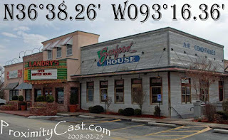
Besides now knowing what side of the rode the building was on, I was also able to make a POSITIVE ID by the signature marquee Landry's seems to have standard on their seafood house restaurants. So, it was now easily obvious that building #2 was the location I needed to identify.

How to Determine Coordinates: Info found here!


BLOCKED_IMAGE-LandrysInBransonE Once you have the green arrow pointing to the spot where you stood to take the photo you can highlight the Latitude and Longitude and paste them directly onto the picture in your Post Processing software.
BLOCKED_IMAGE-LandrysInBransonF Then you can edit the pasted coordinates as desired. Here I replaced the + with a "N" for northern hemisphere for the latitude, and I replaced the - with a "W" for the western hemisphere for the longitude portion. I also removed the comma then simply resize the image for uploading and we are good to go with the use of a GPS.

I hope this entry will be found useful and I look forward to seeing the places you contribute!


Till next time,
ciao my friends!