


by: Winston Churchill (1874-1965)
British prime minister.
PickEvac
PickEvac was the program that got ProximityCast started on its journey.
I took my first computer science course in the mid 80's. It was an introductory programming course using PASCAL. I really enjoyed the course and made an “A”. I considered computer science as a major, but my crystal ball was busted. I figured the job would never amount to more than $25K a year and being stuck in some drab office somewhere.
In the Fall of 1990 I took a job as an EMS (Emergency Medical Services) Helicopter Pilot for a small outfit in the Midwest. There I saw a real need and caught a vision for a program that would solve that need: Pick~E~vac.
The dispatchers for this small outfit sat in a room about the size of a large walk-in closet. They had a large map on the wall covering their service area. Whenever a request for a flight would come in they took a small book that contained the Latitude and Longitude coordinates of all the communities in the company's service area. The dispatcher would determine the coordinates of the nearest community to the scene and plot the location on the large wall map. The the dispatcher would visually determine which base was the closest to the scene and launch them.
Anyone who has manually plotted Latitude and Longitude coordinates knows it is not a simple task. I said, “There has got to be an easier way!” The vision for PickEvac was conceived.
I had a C compiler but had never coded in C. My attempts to learn this language was like hitting a brick wall. (I can now code in C since I found a book that helped me make the hurdle.) So I broke-down and purchased a PASCAL compiler.
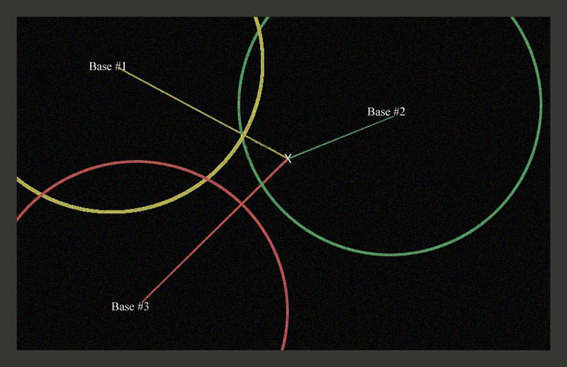
PickEvac was soon born. The dispatchers loved it! The scene coordinates were entered into the program which did a ProximityCast of the companies three bases. The closest base was displayed with a green seventy nautical mile circle drawn around it and a green course line drawn to the scene showing distance and heading. The next closest base was displayed in yellow the same way, and the farthest base was displayed in red.
This program was donated to the company and actively used by the dispatchers until the company expanded to more than three bases.
...and the journey just continues.
No comments:
Post a Comment