ProximityCast.com

Friday, April 2, 2010

the Beginning

The empires of the future are the empires of the mind.
by: Winston Churchill (1874-1965)
British prime minister.
Pick Evac

PickEvac


PickEvac was the program that got ProximityCast started on its journey.


I took my first computer science course in the mid 80's. It was an introductory programming course using PASCAL. I really enjoyed the course and made an “A”. I considered computer science as a major, but my crystal ball was busted. I figured the job would never amount to more than $25K a year and being stuck in some drab office somewhere.


In the Fall of 1990 I took a job as an EMS (Emergency Medical Services) Helicopter Pilot for a small outfit in the Midwest. There I saw a real need and caught a vision for a program that would solve that need: Pick~E~vac.


The dispatchers for this small outfit sat in a room about the size of a large walk-in closet. They had a large map on the wall covering their service area. Whenever a request for a flight would come in they took a small book that contained the Latitude and Longitude coordinates of all the communities in the company's service area. The dispatcher would determine the coordinates of the nearest community to the scene and plot the location on the large wall map. The the dispatcher would visually determine which base was the closest to the scene and launch them.


Anyone who has manually plotted Latitude and Longitude coordinates knows it is not a simple task. I said, “There has got to be an easier way!” The vision for PickEvac was conceived.


I had a C compiler but had never coded in C. My attempts to learn this language was like hitting a brick wall. (I can now code in C since I found a book that helped me make the hurdle.) So I broke-down and purchased a PASCAL compiler.


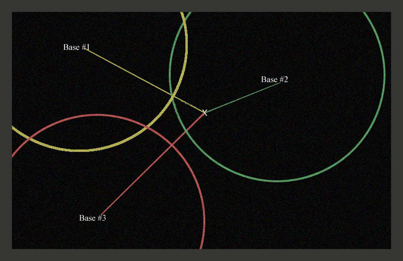
PickEvac was soon born. The dispatchers loved it! The scene coordinates were entered into the program which did a ProximityCast of the companies three bases. The closest base was displayed with a green seventy nautical mile circle drawn around it and a green course line drawn to the scene showing distance and heading. The next closest base was displayed in yellow the same way, and the farthest base was displayed in red.


This program was donated to the company and actively used by the dispatchers until the company expanded to more than three bases.


...and the journey just continues.

Monday, March 29, 2010

A ProximityCast Restaurant Rendezvous

Pleasure disappoints, possibility never. And what wine is so sparkling, what so fragrant, what so intoxicating - as possibility?
by: Soren Kierkegaard (1813-55)
Danish philosopher

Cafe Pontalba

So you find that special restaurant that you would like to take that special person out to eat at... You want to build the anticipation for the special moment and give that special person a sense of the ambiance you two will enjoy at the chosen place...

Now you search ProximityCast.com and find some kind user has already submitted a nice picture of the current favored restaurant. So you go to the Establishment Details page to get some goodies to email your special someone...

Click Pic to see a Larger Image


Cafe Pontalba

In the Top Right Hand Corner you click the "Authorized for Social Sharing" button so you can easily copy a link to the picture to email to that special someone...
http://www.proximitycast.com/aGem/contributor/dave/photos/pce1807.jpg

Next you click the "Establishment Website" link just under the "Authorized for Social Sharing" button to find a menu...
http://www.neworleansrestaurants.com/cafepontalba/menu.html
Cafe Pontalba Menu
Cool! The Establishment Website has a menu...
No surprises! You have an idea of what to order and what it will cost so both you and that special someone can experience Deja Vu upon Arrival all thanks to ProximityCast.com

And you thought Google's Street View was cool... Well, it is... Enter the coordinates from the ProximityCast picture N29°57.44' W090°3.82' into Google Maps and compare the two...

Yep, this is the one! Enter the coordinates into your GPS so you know you will arrive at the correct spot and not some bogus street address mislocated spot...

Your special someone responds back after sending the email with all the appropriate data for making a good decision...

The rendezvous is set...

SHUCKS...
The restaurant of your dreams cannot be found in ProximityCast...
What to do, what to do?
Wow! Anyone can register and enter a location picture into ProximityCast.com/register

The best part, geographic coordinates work the same way anywhere in the world...
Street addresses vary from country to country and are often wrongly located on Google Maps and others...
What kind of useful, exotic, or interesting restaurants can you submit?

Founder out...ciao

Saturday, March 27, 2010

Ideas are useless unless used

Ideas are useless unless used.
by: Theodore Levitt (b. 1925)
U.S. management theorist, writer, and editor.

ProximityCast.com was born as only an idea. A remarkable set of events caused it to be birthed into a reality. It is still only an infant, but it has seen the light of day.

I personally use ProximityCast. I also use and enjoy Google Maps and Street View. ProximityCast can get you there quick if you know how to Navigate the Site. I'll get to that toward the end of this post, but now I'll share a small story.

I love GPS and the navigational possibilities it provides. As a helicopter pilot I cut my teeth on navigating before GPS became a reality. A fact of life back then was that it didn't matter how smooth and talented a pilot was at manipulating the controls, if he couldn't navigate he was worthless. Successfully getting to where you need to go is more important than a smooth ride. A pilot who could do both was "Top Shelf".

GPS changed all of that. Now it doesn't matter if a pilot has no navigational skills. As long as he can plug in the correct numbers into his/her GPS he/she is good to go! Any dummy can do it. GPS was the solution to prevent DMZ overflights into North Korea. GPS drives EMS. I loved navigating without GPS. Dropping into an LZ (landing zone) for the first time just by reading a topo map from tree top height is quite a thrill! But now all that is obsolete thanks to GPS. I still love GPS and what it allows us to do. Simply Awesome!

Have you ever had a street address fail you on Google Maps? I have. GPS coordinates are ten times better especially when they are certified correct. ProximityCast gives you that. Submitters will receive an accuracy rating as soon as we get a plethora of users making a photographic contribution. With a submitter accuracy rating you can know who to trust and who to be skeptical of.

Expect "deja vu upon arrival" and NOT the disappointment upon arrival a street address sometimes gives you.

Okay, here's the easy way to get from ProximityCast to Google StreetView of your Establishment of Choice!

Like "Norm's Diner" in Groton, CT:


Norm's Diner Groton CT

Click the MAP VIEW button at the top of the 6 pack of Cast Results:
Norm's Diner

Once in the MAP VIEW click on the Establishment Picture you wish to view in Street View and then click "Directions" on the PopUp to go into the actual Google Maps Site:
Norm's Diner Groton CT
From there if you are familiar with Street View you can see if the area is covered and click on the "B" marker then "Street View" to see how the two compare.
Norm's Diner looks pretty good. What do you think?

I didn't create ProximityCast just for me, but for all of us. Check it out, try it out, and let me know what you think. I am interested in making it a site you like to use!

Thanks,

Founder out...ciao

Wednesday, March 24, 2010

Considering Something Ideal

When you consider something "ideal", you lose the opportunity to improve it.
by: Shoji Shiba (b. 1933)
Japanese academic and author.

ProximityCast is not "ideal" yet. If you know of a location based service that is, please leave a comment of how I can look at it and why you think it is ideal.


ProximityCast does meet its basic goals even at this stage:

  • Location based service where users can add content and correct content for everyone's benefit.
    • Try doing that with the Points of Interest in your GPS


  • Provide a quality picture so you know what your destination looks like before you get there.

  • Provide location's Latitude and Longitude on the picture.
    • Once again, this acts as the Photographer's certification that if you arrive at the coordinate location you will see what is in the picture. Try doing that with a Street Address in a Location Based Service; sometimes they get you there, sometimes they don't.


ProximityCast is following the Wikipedia model now as in relying on user's input. Anyone have any tips for me as to how to get more users to input pictures?

Monday, March 22, 2010

On the Menu: The "Tour" item

The "tour" item is the first menu item on the bottom horizontal menu on the Main Page!

This is some of what you'll see there:

How to do a ProximityCast Search!


  1. Enter Cast Initiation Point


    • Enter a location to search from.

      • Your home town.

      • A Street Address

      • A Latitude and Longitude


    • Click help for details.


  2. Select Desired Category

    • The top box uses autosuggest to help you find what you want fast.

    • The bottom drop down box lets you browse all available categories when you are unsure of what you want.


  3. Click "Perform ProximityCast"


    • This will take you to your CastNet Results


Understanding the Search Results Page!


  1. Always shows what you entered into the Cast Initiation Point box.

  2. Clicking the ProximityCast.com logo image always returns you to the search page.

  3. Shows the Latitude and Longitude of your Cast Initiation Point.

  4. Shows the "straight line" distance from the Cast Initiation Point to the Establishment that has the focus.

  5. The Cynosure Image!

    • Initially this is the closest establishment to your Cast Initiation Point.


    • Clicking this picture will take you to the Details Page for the shown establishment.


  6. Shows the database coordinates in all three formats for easy comparison with the coordinates shown on the cynosure image.

    • This is IMPORTANT because it lets you discover errors before traveling to a chosen destination.
      • Coordinates on the image serve as the photographer's certification that the location is correct.

      • A discrepancy usually indicates an error was made during coordinate entry into the database.


  7. Allows you to perform another search using the the cynosure image as the Cast Initiation Point.

  8. Allows registered users to flag data that has changed or is in error.

  9. Thumbnail of all establishments returned in the ProximityCast. Clicking any thumbnail makes it the cynosure image.

  10. Takes you to a Google Map mashup where you can visually see where all establishments are in reference to the Cast Initiation Point.

    • Get Driving Directions from the Cast Initiation Point to any selected establishment.


Now you can Quickly Master ProximityCast.com!

Saturday, March 20, 2010

ProximityCast on the iPhone

The Safari Lite Browser on the iPhone and the iTouch is pretty nice. This is a picture of ProximityCast's home screen.

I find I prefer sites on the Safari Lite Browser that have not been optimized for mobile devices due to the ability to zoom in and out which is lost with mobile device optimization.

Making a ProximityCast is as EASY as 1. 2. 3....


  1. Enter your Cast Initiation Point ~ the place from where you wish to search.
    • ProximityCast takes Lat/Long or Street Addresses

  2. Enter your desired search category
    • Simply start typing what you want. e.g. cof...ProximityCast will complete your selection cofFEE

    • or use the Category Selector to browse all available Categories

  3. Click or touch: Perform Proximity Cast


Then view your results!


ProximityCast is loaded with features which require a little time for familiarization, but once that is done... It is super easy to use.

Compare a ProximityCast Establishment Picture with a picture from Google's StreetView. I really like street view, but the pictures are not always the greatest.

ProximityCast is in BETA and can use input so we can plan the best improvements to meet your needs.

Till next time,

Founder out!...ciao

Friday, March 19, 2010

Aiming for the "B" Quadrant ~ Rich Dad/Poor Dad

In Robert Kiyosaki's book he describes the four quadrants income can come from. E/S/B/I...
Rich Dad Poor Dad
ProximityCast is currently in the "H" quadrant. The "H" quadrant doesn't produce any income and it is called a Hobby. Even though it is only a Hobby at this point in time being developed on a bootstrapper's budget, I have my sights on the "B" quadrant.
I have been in the "E" quadrant all of my working life. This is the employee where you derive your wage by working for someone else. It is hard to really get ahead as an employee. Not impossible, just difficult. Then there is the "S" quadrant which is for the self employed. The self employed is mostly just a glorified employee. The biggest benefit for the self employed is that they don't have a boss they have to answer to because they are the boss. The biggest drawback to the "S" quadrant besides having to work twice as hard and wear multiple hats than the typical employee is that once your time on this earth is all said and done, so is the business you worked so hard to create. Basically you are the business. When you cease to exist, so does the business. Currently ProximityCast would be in this quadrant if it was making any money.
Then there is the "I" quadrant. I could use some people that are players in the "I" quadrant to help move ProximityCast into the "B" quadrant. I've had an interest in the "I" quadrant which is all about investing. To get into the game you have to have marbles in your bag.
Now the "B" quadrant is the business quadrant. Many in the "S" quadrant may feel they are players in the "B" quadrant, but there is a BIG difference. The "S" quadrant always requires the main player's presence where the "B" quadrant does not once the system is set up. I know ProximityCast has all the raw ingredients to become a system that can exist long after I'm gone. Whether or not I will be successful getting it there is another story. But, I press on.

Here are my weak links that impede progress as I see it.


  1. I am a solo founder.

  2. For my family's sake I choose to live in the Ozarks.

  3. I'm working on a bootstrap budget.


#1 just fell out like that. My buddy in school whom I invited couldn't grasp the vision. I'd rather fly alone than have someone on-board that is not a true believer. I'm not opposed to having another one or others come on-board if they can be true believers and bring something to the table worthwhile. That something does not have to be technical skills. Those can be hired. Business savvy, a vision, able to be a team player with a focus on developing the system that can enter and be a real player in the "B" quadrant, are things I'd consider as valuable and would welcome to the team, if they are out there.

#2 kinda just worked out like that too. It's where I found myself when the idea began to come together. From what I've learned there are better places to be in the USA if you want to establish a "B" quadrant entity. I'm not opposed to moving, but the cards have to be ready to be played. I'd even consider Singapore or Hong Kong if that proved to be the true home for ProximityCast which is viable world wide.

#3 There are several ways I can see where that could change. I looked over a "Loan Package Development for New Business" for the U.S. Small Business Administration recently. I don't believe that is going to happen. I'm a free man right now where working on ProximityCast is a labor of love. I'm free to do it or not do it. I'd shift gears, but only with a deal that will squarely put ProximityCast into the "B" quadrant as quick as possible where it could continue on with or without me. I may be wrong, but I don't think a SBA loan would do that. So, I'll be content to creep along until something else takes ProximityCast into the "B" quadrant. Or not...